
Microsoft releases 18M building footprints in Africa to enable AI Assisted Mapping
In the last ten years, 2 billion people were affected by disasters according to the World Disasters report 2018. In 2017, 201 million people needed humanitarian assistance and 18 million were displaced due to weather related disasters. Many of these disaster-prone areas are literally “missing” from the map, making it harder for first responders to prepare and deliver relief efforts.
Since the inception of Tasking Manager, the Humanitarian OpenStreetMap Team (HOT) community has mapped at an incredible rate with 11 million square kilometers mapped in Africa alone. However, large parts of Africa with populations prone to disasters still remain unmapped — 60% of the 30 million square kilometers.
Under Microsoft’s AI for Humanitarian Action program, Bing Maps together with Microsoft Philanthropies is partnering with HOT on an initiative to bring AI Assistance as a resource in open map building. The initiative focuses on incorporating design updates, integrating machine learning, and bringing new open building datasets into Tasking Manager.
The Bing Maps team has been harnessing the power of Computer Vision to identify map features at scale. Building upon their work in the United States and Canada, Bing Maps is now releasing country-wide open building footprints datasets in Uganda and Tanzania. This will be one of the first open building datasets in Africa and will be available for use within OpenStreetMap (OSM).
In Tasking Manager specifically, the dataset will be used to help in task creation with the goal of improving task completion rates. Tasking Manager relies on ‘ML enabler’ to connect with building datasets through an API. This API-based integration makes it convenient to access not just Africa building footprints, but all open building footprints datasets from Bing Maps through ML Enabler, and thus the OpenStreetMap ecosystem.
“Machine learning datasets for OSM need to be open. We need to go beyond identifying roads and buildings and open datasets allow us to experiment and uncover new opportunities. Open Building Dataset gives us the ability to not only explore quality and validation aspects, but also advance how ML data assists mapping.”
– Tyler Radford (Executive Director, Humanitarian OpenStreetMap Team)
Africa presented several challenges: stark difference in landscape from the United States or Canada, unique settlements such as Tukuls, dense urban areas with connected structures, imagery quality and vintage, and lack of training data in rural areas. The team identified areas with poor recall by leveraging population estimates from CIESIN. Subsequent targeted labeling efforts across Bing Maps and HOT improved model recall especially in rural areas. A two-step process with semantic segmentation followed by polygonization resulted in 18M building footprints — 7M in Uganda and 11M in Tanzania.
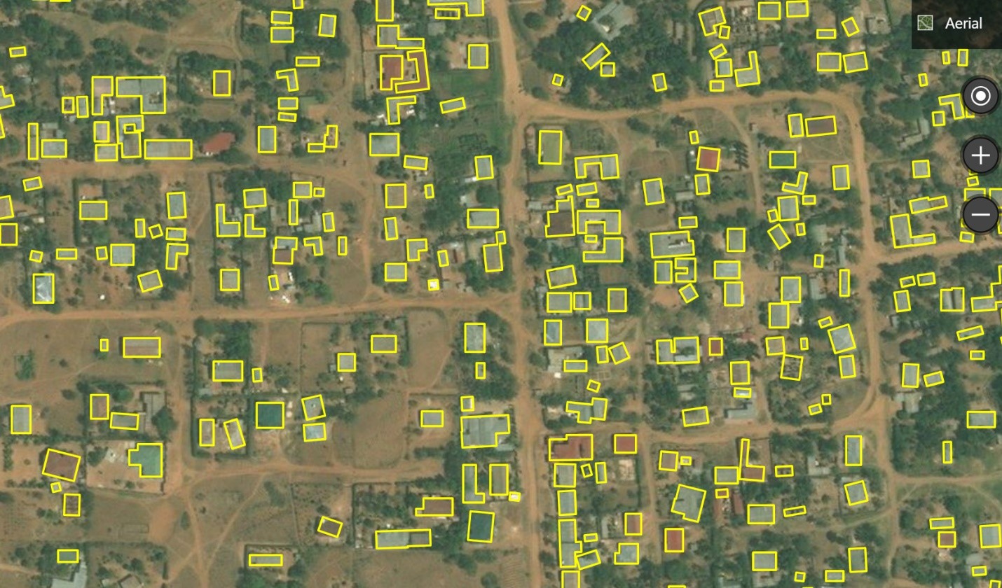 Extractions in Musoma, Tanzania
Bing Maps is making this data open for download free of charge and usable for research, analysis and of course, OSM. In OpenStreetMap there are currently 14M building footprints in Uganda and Tanzania (the last time our team counted). We are working to determine overlaps.
We will be making the data available on Github to download. The CNTK toolkit developed by Microsoft is open source and available on GitHub as well. The ResNet3 model is also open source and available on GitHub. The Bing Maps computer vision team will be presenting the work in Africa at the annual International State of the Map conference in Heidelberg, Germany and at the HOT Summit.
– Bing Maps Team
Source: Bing Blog Feed