FIT and hhpberlin Build Life-Saving Fire Safety Solution Powered by Bing Maps
Partners combine Augmented Reality and Digital mapping to create a life-saving application on Windows Azure. This Interview with the Fichtner IT Consulting (FIT) architects explains how they enable rapid information sharing to provide first responders with up to the minute logistical details during rescue operations.
FIT is the IT competency center of the globally active Fichtner Group. FIT advises and implements powerful IT solutions for technical networks, plants and infrastructure and combines industry knowledge and process know-how with the latest technology competency to provide innovative and cost-effective solutions. Working with hhpberlin, one of Europe’s market leaders in precautionary fire protection concepts, FIT developed a life-saving fire safety solution called ARE firechief.
ARE firechief is a Sustainable Safety Platform for Communities that provides relevant security information in a digital, interactive and visually attractive way in near or realtime, empowering user groups like fire fighters, facility managers or hotel guests to make better decisions in emergency situations based on actual data. It helps these users quickly find security infrastructure assets, rescue routes and essential information.

The Microsoft Bing Maps for Enterprise platform is used as the essential front end module for the user and provides data visualization, geocoding and routing functionality while the complete Azure infrastructure (i.e., SQL Azure / Azure Storage, Azure Active Directory, ExpressRoute and Azure ExpressRoute) handles data management and process workflows. ARE firechief is a true showcase of integrated Microsoft technologies.
“The Microsoft Bing Maps for Enterprise platform empowered us to realize next generation fire engineering with the ARE firechief solution enabling new scalable, cloud-based business models for our customer, hhpberlin,” says Peter Brack, Director Business Geo Intelligence at FIT.
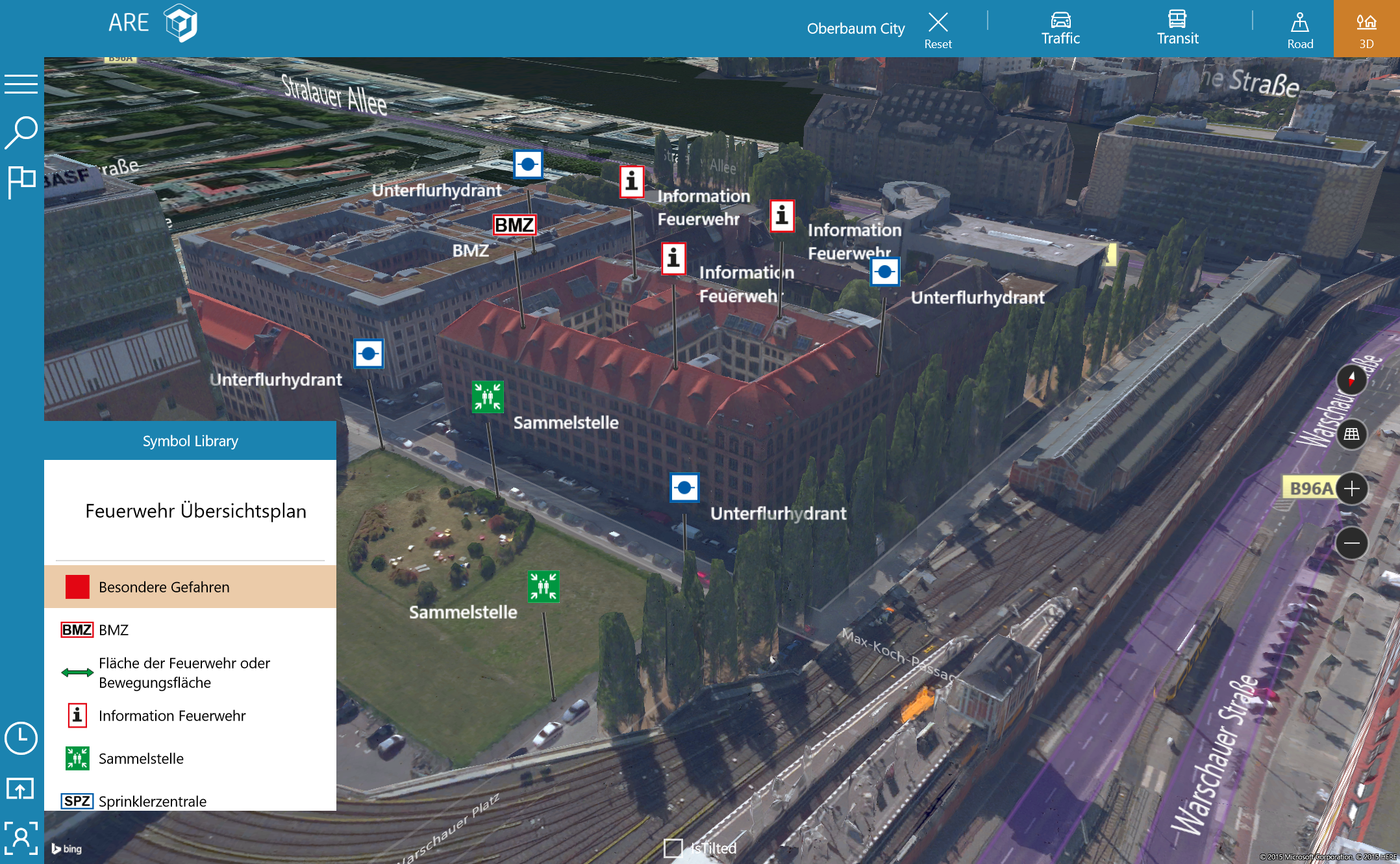
The idea for ARE firechief came about as hhpberlin found that fire fighting, escape and rescue plans are typically static, paper-based plans that can be ineffective in emergency situations. Printed plans often hung on walls in shopping malls, hotel room doors, and in train stations can be difficult to find and understand in an emergency. The “ARE” in ARE firechief stands for Augmented Reality Environment, and with ARE firechief, the Bing Maps platform is integrated as the basic element of the Graphical User Interface displaying infrastructure assets on high-resolution aerial 3D imagery. Also, it fully supports the immersive geocoding and routing capabilities to help enable pedestrian and vehicle navigation and orientation onsite for quicker evacuation and response in emergency scenarios.
Below is Q&A with the FIT team about how they are using Bing Maps in their solution:
What are you using Bing Maps for Enterprise for?
ARE firechief uses Bing Maps in conjunction with the complete Azure infrastructure (i.e., SQL Azure / Azure Storage, Bing Maps for Enterprise, Azure Active Directory, ExpressRoute and Azure ExpressRoute) to enable modern and scalable applications. To particularly support (mobile) devices hhpberlin and Fichtner IT Consulting choose the Universal Windows Platform as prioritized platform for mobile users and a HTML5/ Javascript ASP responsive website as an administration tool including functionality to update infrastructure assets. The HTML5 website platform has been developed using the Bing Maps AJAX API while the Universal Windows Platform app was developed with several UWP Bing Maps powered views to assist users, including personnel from security companies, fire departments, venue staff and even people fleeing from emergency situations. The application utilizes the following features of the Bing Maps platform in the multi-layered views for users:
- Augmented Reality View
- 3D View
- Bird’s Eyes Views
- Offline Maps

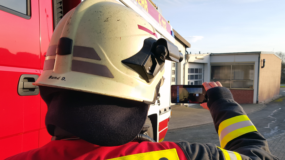
All layers include (augmented) security relevant information (e. g., rescue plan, emergency exits, fire extinguisher, alpha-numeric attributes etc.) displayed on screen plus the precise location of the user. Functionality of course includes augmented reality camera interactivity in terms of display of information based on user position and movements, pedestrian and car routing and an automatic switch of views in case the device is tilted or offline. The immersive Bing Maps routing capabilities are – of course – used to enable evacuation scenarios as well as drive-time calculations for emergency service teams.
Why did you choose Bing Maps for Enterprise in your solution? (E.g., support, features, etc.)
hhpberlin and FIT chose Bing Maps for Enterprise as a web-based mapping platform because of its perfect and seamless integration with Universal Windows Platform and the Azure Cloud Platform services, its coverage with high-resolution aerial imagery, the available 3D models for relevant cities and it’s immersive functionality with respect to geocoding and routing. It additionally provides a massive set of point-of-interests by the Spatial Data Service API, including a perimeter search to recognize infrastructures at risk in the nearby surrounding area. For use in emergency situations when Internet connectivity might be weak, the possibility to display maps in the form of comprehensive offline maps is essential and automatically recognized and switched on by the API.
Another plus has been the professional enterprise support of the platform and the profound documentation of the available for the required APIs. Bing Maps has existed since 2001 and is a proven interface for business-critical applications.
What benefits are you seeing?
ARE firechief clearly shows what is possible when actors and organizations share information and enable barrier-free access. Various actors and organizations can participate, from the caretaker who determines that a hydrant is broken right up to the fire brigade who affects the repair of the same. Digital fire protection documents help, for example in an emergency situation where emergency personnel have to make quick and decisive decisions. In order to shorten the time span until the rescue service arrives, an app alerts volunteers in the near vicinity. By means of a quality management system, the fire brigade is always informed in real-time about the availability of the employees as well as the condition of the buildings and equipment in question.
hhpberlin and FIT are convinced that the innovative Augmented Reality Environment (ARE) solution will change the world of fire protection documents in terms of interactivity, mobility and scalability. ARE is part of the first one-stop shop ”safetynext.one” for fire engineering tools like fire-framework (modelling, simulating and analyses of fires), Emergency Reporting (Fire Records Management), crowd:it (pedestrian flow simulation) and many more.
Our goal for the future is to help shape and promote Secure Smart City. The cities of the future will be intelligent, networked and more secure. To achieve this, it requires courage to change. Digitization is the fuel that can improve civilian security, to make the world a safer place.
To learn more about ARE firechief, go to https://www.safetynext.one/en/tool/firechief.
To learn more about Bing Maps and see other customer stories go to https://www.microsoft.com/en-us/maps.
Source: Bing Blog Feed
