Facebook’s RapiD Editor Now Includes Microsoft Building Footprints
Over the past few years, Bing Maps has generated high quality building footprints leveraging the power of AI. In September 2019, our team released another Open Buildings Dataset. However, so far there has been no mechanism to get such data into the hands of mappers and speed up the process of mapping.
When Facebook reached out to our team, right around the latest buildings data release, to partner on enriching their RapiD editor with Microsoft Buildings, it was an obvious match. Microsoft is a partner in the Missing Maps initiative, which works to update OpenStreetMap (OSM) to map the largely unmapped parts of the world while RapiD is a tool that makes mapping even easier!
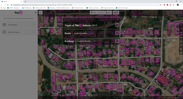
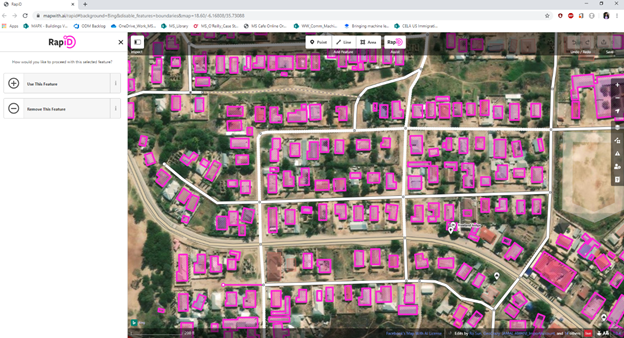
Facebook's RapiD editor is an enhanced version of the popular OSM editing tool, iD. RapiD editor puts AI-generated features (e.g., Facebook Roads or Microsoft Buildings) at the fingertips of mappers allowing them to map more quickly, and more importantly, produce a higher level of detail, quality, and accuracy on the resulting map. RapiD is part of Facebook's Map With AI, an AI-powered set of services and tools the company released publicly in the summer of 2019. Check out the video showing the difference between iD and RapiD.
Facebook and Bing Maps teams worked closely together to integrate Microsoft's buildings dataset into RapiD, including sharing the results with communities at various open mapping conferences like State of the Map (SOTM) US, Humanitarian OpenStreetMap Team (HOT) Summit and SOTM International. The response from these events was very encouraging! Facebook's RapiD with Microsoft's buildings included went live at the end of November 2019, and we are excited to be a part of the effort. We’re happy to announce that all of Microsoft's open building datasets are now available from within the RapiD Editor.
RapiD users now have easy access to a massive collection of approximately 155 M building polygons from Microsoft, outlining structures derived using computer vision models on satellite imagery. While this is great progress, there are still too many places around the world that remain unmapped. AI-assisted mapping can help accelerate the process, taking away the tedious pieces and allowing mappers to add valuable context to maps.


Microsoft has made significant investments in deep learning, computer vision and AI that have been applied to mapping. We are working to further increase the coverage of building footprints with releases of data in the United States, Canada, Tanzania and Uganda with more to come. We'll continue to share any new open buildings with the community through RapiD.
To learn more about our building footprint dataset, how it is derived from imagery, and download it for yourself, go to our GitHub Projects:
- United States – https://github.com/Microsoft/USBuildingFootprints
- Canada – https://github.com/Microsoft/CanadianBuildingFootprints
- Tanzania and Uganda – https://github.com/microsoft/Uganda-Tanzania-Building-Footprints
For more information about the Bing Maps Platform, go to www.microsoft.com/maps. And you can check out the latest updates to the Map With AI service, including expanded coverage, new tools, and our partnership here: https://tech.fb.com/map-with-ai-updates/.
– Bing Maps Team
Source: Bing Blog Feed
