
Microsoft Releases 125 million Building Footprints in the US as Open Data
Bing has made very significant investments in the area of deep learning, computer vision and artificial intelligence to support a number of different search scenarios. The Bing Maps team has been applying these techniques as well with the goal to increase the coverage of building footprints available for OpenStreetMap. As a result, today we are announcing that we are releasing 124 Million building footprints in the United States to the OpenStreetMap community.
The Maps team has been relying on the Open Source CNTK Unified Toolkit which was developed by Microsoft. Using CNTK we apply our Deep Neural Networks and the ResNet34 with RefineNet up-sampling layers to detect building footprints from the Bing imagery.
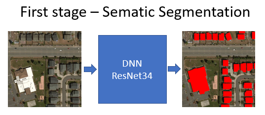
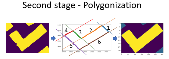
We remove noise and suspicious data (false positives) from the predictions and then apply a polygonization algorithm to detect building edges and angles to create a proper building footprint.
Using this approach we extracted 124,885,597 footprints in the United States. In OpenStreetMap there are currently 30,567,953 building footprints in the US (the last time our team counted) both from editor contributions and various city or county wide imports. Bing is making this data available for download free of charge.
You can read more about this work and directly download the data from GitHub. The CNTK toolkit developed by Microsoft is open source and available on GitHub as well. The ResNet3 model is open source and available on GitHub. Our Bing Maps computer vision team will be presenting this work at the annual International State of the Map conference in Milan, Italy.
– Bing Maps Team
Source: Bing Blog Feed